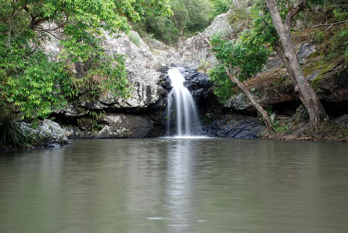
Where the Blackall Range drops away
The car park sits at the very end of Kondalilla Falls Road. Beyond the picnic area, the ridge-top farmland gives way to tall eucalypts. A few minutes down the track the canopy closes over and the air turns damp. Piccabeen palms crowd the gullies, strangler figs wrap the older trunks, and Skene Creek runs over flat sandstone before it falls off the edge of the Blackall Range.
The name Kondalilla is usually translated as “rushing waters” in the language of the area’s Aboriginal people. That fits best in the wetter months, when the falls run hard into the valley below. In a dry spell the flow shrinks to a thin ribbon. The forest walk is still worth doing then; you just get less spray at the bottom.
This is a well-known park with a steady stream of visitors, not an empty trail. Plan around that and you will enjoy it far more.
Choosing your loop
All three main walks start from the same day-use area, so pick one on the day based on time and knees. These are the routes Queensland Parks and Wildlife Service signposts from the car park:
- Picnic Creek circuit: a short rainforest loop of about 1.7 km. It suits families and anyone wanting the forest without the big descent.
- Rock pools walk: around 2.1 km return to the pools above the falls. You get the swimming hole and creek scenery with far fewer stairs.
- Kondalilla Falls circuit: about 4.7 km, dropping to the base of the falls and climbing back out. Allow two to three hours.
The falls circuit is the one people come for, and it is harder than it looks on the map. Most of the descent is on stone and timber steps, and every one of them has to be climbed again on the way out. Take water even on a cool day. After rain, check your ankles for leeches when you stop.
The Sunshine Coast Hinterland Great Walk also passes through the park. Day walkers will see its markers along the way.
The rock pools above a 90-metre drop
Kondalilla is unusual because the swimming happens at the top. Skene Creek pools in shallow sandstone basins just upstream of where it plunges roughly 90 metres into the valley. The editorial description mentions both a swimming hole and a lower rock pool. On a warm afternoon these are where most visitors end up.
The setting is the danger. The rock near the lip is smooth, often wet and slippery with algae. People have been seriously injured and killed after going beyond the fences and signs. Swim only in the marked pool areas and never wade toward the edge. Keep children within arm’s reach.
Water quality in creek pools changes after heavy rain and in long dry spells. Rangers post notices at the track head when swimming isn’t advised. Read them before you take your shoes off. Never jump or dive in, because the depth is hard to judge through tannin-stained water.

Getting to Flaxton and the car park question
Kondalilla Falls Road turns off the Montville–Mapleton Road on the ridge just north of Montville. There is no public transport to the trailhead, so you need a car, a tour or a long walk on the Great Walk. From Brisbane, plan on about an hour and a half driving up the Bruce Highway and into the range.
The road up the escarpment is narrow and winding. Tour coaches and cyclists share it with you. Expect to slow down through Montville village, especially on weekends.
The car park is the real bottleneck. It isn’t large, and on busy days cars queue for spaces or end up on the verge further back. Don’t park across driveways or on the roadside where signs say not to. If it’s full, drive on to Montville for an hour and try again.
Beating the weekend crowd at Kondalilla
Weekends are full all day. Our foot-traffic data shows the busiest weekend period runs from 8am to 8pm, which covers every sensible hiking hour. If Saturday or Sunday is your only option, accept company on the steps and try for a car park space early in that window.
A weekday is the simpler fix. With no measured quiet window to point to, the reasoning is simple: school groups and day trippers bunch up in school holidays and on weekends. Outside those times, a weekday morning usually means a shorter wait for parking and room at the rock pools.
A few habits regulars stick to:
- No dogs. Pets aren’t allowed in Queensland national parks, including the trails and picnic area.
- Carry your rubbish out. That includes fruit scraps, which attract brush turkeys that already patrol the picnic tables.
- Stay on the formed track. Shortcuts on the switchbacks wear away the slope and are a common cause of slips.
- Give way on the stairs. People climbing up are working harder, so step aside for them on narrow sections.
- Leave drones at home. Flying in national parks generally needs a permit.
There’s no gate or ticket booth, and Google currently lists the park as open 24 hours. Treat it as a daylight walk all the same. The forest track goes dark early under the canopy, and the base of the falls is no place to be fumbling with a phone torch.
Pairing it with Montville and Maleny
Kondalilla works best as the active half of a hinterland day. Montville is a few minutes south along the ridge. Its main street is lined with galleries, cafés and craft shops, with lookouts over the coastal plain toward the ocean.
Further along the range, Maleny has the Mary Cairncross Scenic Reserve, a smaller rainforest remnant with views of the Glass House Mountains. Baroon Pocket Dam, near the southern end of the Great Walk, sits between the two towns. North of Flaxton, the road continues to Mapleton and the Mapleton Falls lookout.
A good order is to walk Kondalilla first while your legs are fresh, then eat lunch in Montville. Finish at a western lookout as the light drops over the Glass House Mountains.
Frequently asked questions
When is the quietest time to visit Kondalilla National Park?
We don't have a measured quiet window for this park. What the data does show is that weekends are busiest from 8am to 8pm, so the whole weekend day is crowded. A weekday outside school holidays is your best bet for easier parking and quieter rock pools.
How long does the Kondalilla Falls walk take?
The Kondalilla Falls circuit is about 4.7 km with a steep descent on steps and a climb back out. Allow two to three hours. The rock pools walk (about 2.1 km return) and the Picnic Creek circuit (about 1.7 km) are shorter options.
Can you swim at Kondalilla Falls?
Yes, in the marked swimming hole and rock pools on Skene Creek above the falls. Stay well back from the edge, never jump or dive, and check the signs at the track head. Rangers post notices there when water quality or conditions make swimming inadvisable.
Where do you park for Kondalilla National Park?
Park in the day-use car park at the end of Kondalilla Falls Road, which turns off the Montville–Mapleton Road near Flaxton. It's small and fills quickly on weekends. If it's full, wait in Montville and come back later rather than parking illegally on the verge.
What else is near Kondalilla National Park?
Montville village is a few minutes south, with cafés, galleries and coastal lookouts. Maleny and the Mary Cairncross Scenic Reserve are further along the range, Baroon Pocket Dam is nearby, and the Mapleton Falls lookout is to the north.
Plan your trip to Sunshine Coast
Australia eSIM & staying connected →
Some links above are affiliate links — if you book through them, Wander Atlas earns a small commission at no extra cost to you. It's how we keep every guide free.
Related guides
 attraction
SEA LIFE Sunshine Coast Aquarium: Travel Guide (4.3★)
 hidden gem
Aussie World: Sunshine Coast Travel Guide (4.3★)
 attraction
Roma Street Parkland: Brisbane Travel Guide (4.7★)
 attraction