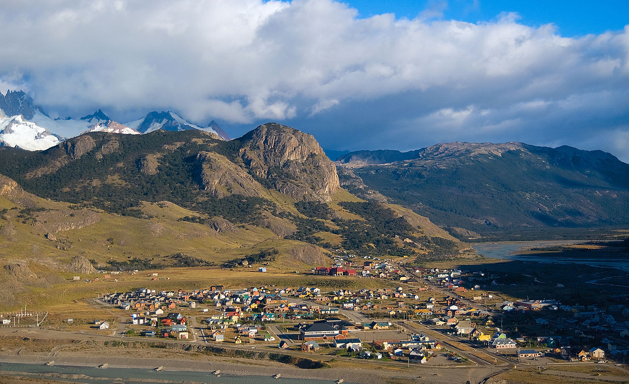
Where the road ends at Fitz Roy
Route 23 stops here. El Chaltén sits at the end of the road where the Río de las Vueltas and Río Fitz Roy meet. Behind it, the granite spires of Cerro Fitz Roy and Cerro Torre rise over the northern sector of Los Glaciares National Park.
The town was founded in 1985, which makes it one of Argentina’s youngest. Argentina later named it the country’s National Trekking Capital. The name comes from the Tehuelche word for Fitz Roy, usually translated as “smoking mountain” because cloud so often streams off the summit.
Most of town lies along Avenida San Martín. Hostels, gear-rental shops, bakeries and microbreweries line it, and the trails start from the ends of the street. You don’t need a car once you arrive.
Getting there from El Calafate
The nearest airport is El Calafate (FTE). From there it is roughly 220 km by road, north on Ruta 40 and then west on Ruta 23. Several bus companies run the trip daily in summer and take about three hours. Book a seat ahead in January and February.
Just before town, the road crosses the Río Fitz Roy and passes the national park visitor centre. Stop there for:
- current trail conditions and closures
- wind and weather forecasts for the high sections
- campsite rules and the park’s leave-no-trace briefing

Picking your trail
Trails leave straight from the village, and most visitors stay two to four nights to fit in the main routes.
- Laguna de los Tres: the classic Fitz Roy viewpoint, a full day of 8–10 hours return. The final hour is a steep, loose climb to the glacial lake at the base of the spires.
- Laguna Torre: a gentler valley walk of about 6–7 hours return to a lake below Cerro Torre, often with icebergs floating in it.
- Mirador de los Cóndores and Mirador de las Águilas: short climbs from the south end of town, good on arrival day or at sunset.
- Loma del Pliegue Tumbado: a long ridge climb with a side-on view of both massifs.
Summer daylight runs late into the evening, so a mid-morning start still works for the long routes. Leaving before dawn for Laguna de los Tres gets you the sunrise glow on Fitz Roy, if the clouds allow.
Trail manners and town logistics
Weather decides everything here. Wind on the exposed ridges can knock a hiker off balance, and the peaks may hide for days. Locals and guides plan around the forecast and keep a spare day so the Fitz Roy hike can wait for a clear morning.
How the town works:
- Cash: there are few ATMs and they can run dry in peak season. Bring Argentine pesos from El Calafate, though many businesses take cards.
- Water: hikers commonly fill bottles from the streams higher up. Never wash or relieve yourself near them.
- Camping: pitch only at the designated park campsites. Fires are banned throughout the park.
- Trail etiquette: stay on the marked path, pack out all rubbish, and give way to people coming down the steep sections.
The common mistake is booking just one night and expecting to see Fitz Roy. Book three if you can.
Frequently asked questions
How do I get to El Chaltén?
Fly into El Calafate (FTE), then take a bus or drive about three hours north via Ruta 40 and Ruta 23. Buses run daily in summer. Book ahead in January and February.
When is the best time to visit El Chaltén?
November to March, the southern summer, when the trails are open, the days are long and the buses run often. Expect strong wind at any time of year.
How many days do I need?
Plan at least two full hiking days, and ideally three or four nights. That covers Laguna de los Tres and Laguna Torre, with a spare day in case cloud hides Fitz Roy.
Which hike is hardest?
Laguna de los Tres. It takes about 8–10 hours return and ends with a steep, loose final climb to the lake below Fitz Roy. Laguna Torre is the easier full-day option.
What should I stop at on the way in?
The national park visitor centre by the Río Fitz Roy bridge, just before town. Staff there have current trail conditions, forecasts and campsite rules.
Plan your trip to El Chalten
Argentina eSIM & staying connected →
Some links above are affiliate links — if you book through them, Wander Atlas earns a small commission at no extra cost to you. It's how we keep every guide free.
Related guides
 attraction
Parque Nacional Los Glaciares: El Calafate Travel Guide
 attraction
Southern Fuegian Railway: Ushuaia Travel Guide (4.5★)
 attraction
Cartel: Ushuaia Travel Guide (4.8★)
 attraction