
Above the caldera at first light
Dawn here comes in layers. At first you see only black sky and a long line of phone screens along the railing. Then the shapes come up out of the mist below you.
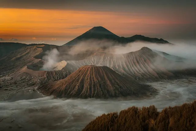
Bromo’s crater sits low and grey, venting a steady plume. Beside it rises the ribbed cone of Mount Batok. Behind both, Semeru, Java’s highest peak, often puffs a small cloud of ash. The whole scene sits inside the old Tengger caldera, a vast basin floored with volcanic sand.
Penanjakan is the high rim where that view lines up best. It’s part of Bromo Tengger Semeru National Park and stands at roughly 2,700 metres, so the air is thin and cold. Thousands of reviewers rate it highly. Very few of them describe having it to themselves.
Getting up the mountain
Nearly everyone comes up in a jeep. Old Toyota Land Cruisers are the standard vehicle, and convoys of them climb the switchbacks in the dark. There are two usual bases:
- Cemoro Lawang (Probolinggo side): the village on the caldera rim, with the most guesthouses and jeep operators.
- Tosari / Wonokitri (Pasuruan side): closer to Penanjakan’s road, and a common route from Surabaya or Malang.
Jeeps drop you below the top. You walk the last stretch uphill past food stalls. Short of breath is normal at this altitude, so take it slowly.
The viewpoint currently shows as open 24 hours. Park access can still close during volcanic alerts or ceremonies, though, so check the official national park site before you travel. Entry fees are posted there and at the park gates.

Claiming your place on the rail
The viewing area is a set of stepped concrete terraces facing the caldera. The front rail fills first. Here’s how the morning usually goes.
- Arrive well before first light. Jeeps leave the villages in the small hours precisely so passengers can get a spot before the crowd builds.
- Stand, don’t sprawl. Tripods and big bags at the front block people behind you. Most visitors shoot handheld and then step back.
- Carry small rupiah notes. The warung sell hot tea, coffee and instant noodles. Vendors also rent jackets and sell beanies and gloves, and cash is how most of that gets paid.
- Agree on the jeep plan the night before. Tours usually bundle Penanjakan, the sand sea and the crater. Confirm the stops and your meeting point, because hundreds of nearly identical jeeps park on the same slope.
If the main deck is packed, ask your driver about the lower viewpoints along the road, such as Seruni Point or King Kong Hill. They give a similar angle on Bromo and Batok.
Down into the sand sea
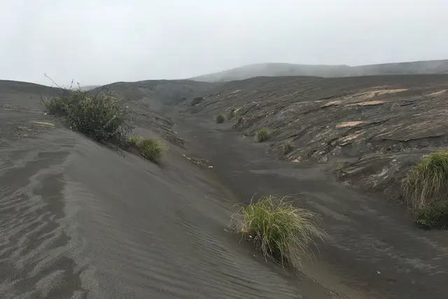
The jeeps go down once the sun is up. They cross the Lautan Pasir, the Sea of Sand, a flat grey plain that crunches underfoot and blows into everything.
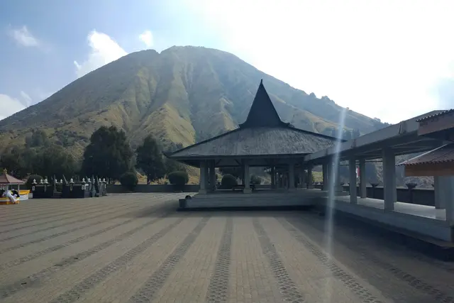
At its centre stands Pura Luhur Poten, a Hindu temple of the Tengger people built of dark volcanic stone. From the parking area you can walk or hire a horse from Tenggerese handlers to the foot of Bromo. Then a long concrete staircase climbs to the crater rim. From the top you look down into a sulphurous, steaming throat.
Bring a scarf or mask for the dust and the sulphur. The temple and crater are sacred to the Tengger community. During Yadnya Kasada, worshippers throw offerings into the crater, and access can change around that ceremony.
Cold, cloud and the calendar
The cold surprises most people. Before dawn, temperatures on the rim can drop close to freezing, especially in the dry months. A down jacket, a hat and gloves are worth more than any camera upgrade.
The dry season, roughly May to October, gives the clearest sunrises. In the wet months, cloud often fills the caldera and can hide the view entirely. Even in the best season, mist is never ruled out.
Plan for a full morning. You’ll spend about an hour at Penanjakan for sunrise, then another two or three hours in the sand sea and at the crater. You can be back in Cemoro Lawang for a late breakfast.
What the view is really like
Be clear about what you’re signing up for. This is a crowd, an early alarm and a cold wait.
The reward is a view that has barely changed since people started climbing up here to watch it: three volcanoes, one of them active, lifting out of a sea of cloud. Accept the company and pack properly. It’s worth doing once.
Frequently asked questions
How do I get to Penanjakan Bromo?
Most visitors take a 4x4 jeep tour from Cemoro Lawang on the Probolinggo side or from Tosari and Wonokitri on the Pasuruan side. Jeeps drive up in the small hours and drop you a short uphill walk below the viewing terraces.
What is the best time to visit Penanjakan?
Go before sunrise in the dry season, roughly May to October, when the skies are clearest. In the wet months, cloud often covers the caldera. Get there well before first light to find a spot at the rail.
How long should I plan for Penanjakan and Bromo?
Plan for about an hour at the viewpoint for sunrise. Then allow two to three hours more for the Sea of Sand, Pura Luhur Poten and the stairs up to Bromo's crater rim. Most tours are finished by late morning.
How cold is it, and what should I bring?
At around 2,700 metres before dawn, temperatures can get close to freezing. Bring a warm jacket, a hat, gloves and a scarf or mask for the sand and sulphur. Vendors at the top rent jackets and sell beanies if you forget.
Is the viewpoint always open?
It currently shows as open 24 hours. The national park can still restrict access during volcanic alerts or the Yadnya Kasada ceremony, so check the official park site before you go. Current entry fees are posted there too.
Plan your trip to Mount Bromo
Indonesia eSIM & staying connected →
Some links above are affiliate links — if you book through them, Wander Atlas earns a small commission at no extra cost to you. It's how we keep every guide free.
Related guides
 hidden gem
Bromo Tengger Semeru National Park: Mount Bromo Travel Guide
 attraction
Sea of Sand Bromo: Mount Bromo Travel Guide (4.8★)
 attraction
Pura Luhur Poten Gunung Bromo: Mount Bromo Travel Guide
 hidden gem