
A Park With a Town Inside It
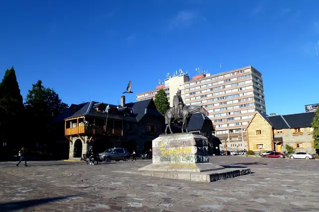
Bariloche does not sit next to this park. It sits inside it. Walk downhill from the Centro Cívico, past its grey stone arcades and dark timber balconies, and Lago Nahuel Huapi fills the end of the street. It is cold and wide, and the far shore is a row of forested ridges.
The park’s administration building stands on Av. San Martín, close to that square. It is the right first stop for trail conditions and maps.
The park grew out of land Francisco “Perito” Moreno donated in 1903. That gift makes it the oldest protected area in Argentina’s national park system. Today it covers more than 7,000 square kilometres across Río Negro and Neuquén provinces. It is a lot of ground: glaciers, volcanic peaks, temperate rainforest and dozens of lakes. You will see only a slice of it, so choose your slice on purpose.
Circuito Chico: The Lakeshore Loop
Most visitors start with the Circuito Chico. It is a paved loop of roughly 60 kilometres that leaves town along Avenida Bustillo and follows the western shore. It works by car, by bike rented from the kilometre-markers area, or partly by city bus.
Stops worth pulling over for:
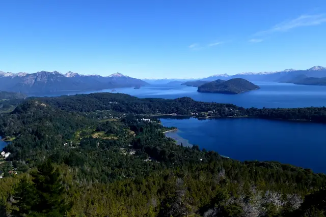
- Cerro Campanario: a chairlift to a summit platform over Lago Nahuel Huapi and Lago Perito Moreno.
- Puerto Pañuelo: the dock for boats to Isla Victoria.
- Llao Llao Hotel: the wood-and-stone hotel on its hill, best seen from the road.
- Punto Panorámico: a roadside lookout over Bahía López.
- Colonia Suiza: a small settlement just off the loop, known for its curanto.
Cycling the loop means rolling hills and narrow shoulders. Start early and allow most of a day.
Up Among the Lenga: Catedral and the Refugios
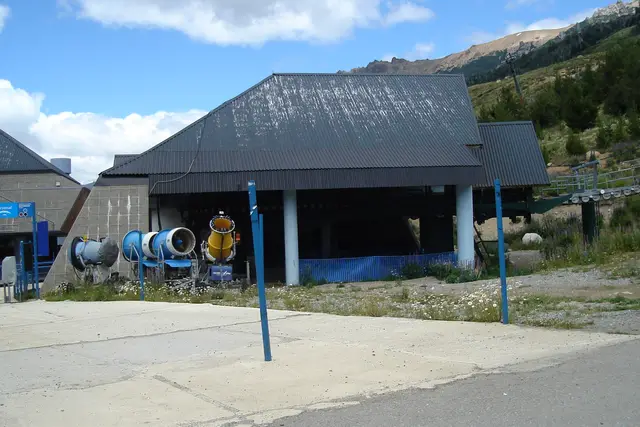
Cerro Catedral looms south-west of town, its summit a crown of granite spires. In winter it is one of South America’s largest ski areas. In summer the lifts carry walkers up, and the trailheads at Villa Catedral open onto the park’s best-known day hikes.
The classic is the walk to Refugio Frey. It climbs through coihue and then lenga forest to a stone hut beside a small lake under the spires. Expect a full day there and back. Fit hikers link Frey to other huts, such as Jakob and Laguna Negra, on multi-day traverses.
Refugios are mountain huts run in partnership with Club Andino Bariloche. They offer bunks, simple hot meals and a stove to sit beside. Club Andino’s office in town has the current state of each hut and route.
The Tronador Road and Its One-Way Clock
Cerro Tronador is the “thunderer”, a glaciated volcano on the Chilean border that stands well above 3,400 metres. It is the reason many people drive the long gravel road past Lago Mascardi to Pampa Linda. The name comes from the boom of ice breaking off its glaciers, and on a warm afternoon you can hear it.
There is one quirk here that catches visitors out. The upper section of the road is too narrow for two-way traffic. It runs one direction at a time on a fixed schedule: uphill in the morning, downhill later in the day. Miss your window and you wait. Check the current timetable at the park office before setting off, and treat it as the backbone of your day.
At the end of the road, Ventisquero Negro is a glacier blackened by rock debris. It calves into a grey meltwater lagoon. From Pampa Linda, trails climb toward Refugio Otto Meiling on the mountain’s flank.
Seasons Run Backwards Here
This is the southern hemisphere, so the calendar flips.
- December to March: summer. The high trails are clear of snow, the refugios are staffed, and the lake is swimmable for the brave. This is the busiest hiking season.
- April and May: autumn. Lenga and ñire forests turn red and gold, and the days get short and sharp.
- June to September: winter. Catedral’s ski season runs, and high trails are snowbound.
- October and November: spring. Wildflowers come out, but snow often lingers on the passes.
The weather swings fast at any time of year. A calm lake morning can turn into wind and sleet above the treeline by afternoon. Pack a shell layer even on a blue-sky day.
Trail Manners in Nahuel Huapi
The park is heavily visited, and it works because people follow a few shared habits.
- Ride the bus with a SUBE card. Bariloche’s city buses take the rechargeable SUBE card, not cash. Line 20 runs along Bustillo toward Llao Llao and Puerto Pañuelo. Line 55 runs to Villa Catedral.
- Register long hikes. For treks beyond the main day routes, the park asks you to register your itinerary before you go. Ask at the office on Av. San Martín how it currently works.
- Respect the fire rules. Patagonian forest burns fast in dry summers. Open fires are restricted to designated sites, and sometimes banned outright. Smokers should carry their butts out.
- Carry everything out. Most huts expect you to take your own rubbish back down.
- Reserve hut beds in summer. In January and February, contact the refugio or Club Andino ahead of time rather than turning up hoping.
- Accept the mate if offered. Groups at huts and viewpoints pass around a gourd of yerba mate. Drink it and hand it back to the person who serves. Saying “gracias” means you are done.
On popular routes like Frey, your best tactic in peak season is simply starting early. Getting onto the trail before the main wave of walkers from town usually means quieter switchbacks and a free spot at the lake.
Shaping Your Days
A sensible first visit runs three to five days. Pick one day each from:
- the lakeshore: Circuito Chico, with an optional boat to Isla Victoria
- the mountains: Catedral, Frey or Cerro Otto
- the far west: Tronador and Pampa Linda
Add Villa La Angostura on the lake’s north shore if you have a car and a spare day. The neighbouring Los Arrayanes forest of cinnamon-barked myrtles is a separate national park.
Wildlife is a quiet bonus. Watch the sky for Andean condors over open ridges. Look for the Magellanic woodpecker, the male’s head a flash of red, in the old-growth forest. The park also protects the endangered huemul deer, which very few visitors ever see.
Frequently asked questions
How do I get into Parque Nacional Nahuel Huapi from Bariloche without a car?
You are already in it. City buses paid with a SUBE card reach the main areas: Line 20 runs along Avenida Bustillo toward Llao Llao and Puerto Pañuelo, and Line 55 goes to Villa Catedral. For Tronador and Pampa Linda, people usually take a tour or hire a car.
What is the best time of year to visit?
December to March is best for hiking and for staffed refugios. April and May bring autumn colour in the lenga forests. June to September is ski season on Cerro Catedral.
How many days do I need?
Three to five days covers the highlights: one for the Circuito Chico, one for a mountain hike such as Refugio Frey, and one for the full-day trip to Cerro Tronador.
Is there anything I need to know before driving to Cerro Tronador?
Yes. The upper road to Pampa Linda runs one way at a time on a fixed schedule, uphill earlier in the day and downhill later. Check the current timetable at the park office on Av. San Martín before you leave town.
Do I need to book the mountain huts?
In peak summer, especially January and February, it is wise to reserve. Contact the refugio or Club Andino Bariloche ahead of time. Also register multi-day treks with the park before you set out.
Plan your trip to Bariloche
Argentina eSIM & staying connected →
Some links above are affiliate links — if you book through them, Wander Atlas earns a small commission at no extra cost to you. It's how we keep every guide free.
Related guides
 attraction
Cerro Campanario: Bariloche Travel Guide (4.9★)
 attraction
Cerro Catedral: Bariloche Travel Guide (4.5★)
 attraction
Centro Cívico: Bariloche Travel Guide (4.6★)
 attraction