A valley most of Sumner Road drives past
Redcliffs is a seaside suburb most people pass through. Traffic on Main Road heads for Sumner’s beach, and few drivers look up at the gully behind the houses. Barnett Park sits in that gully: an open reserve that narrows into a bush-lined valley climbing into the Port Hills.
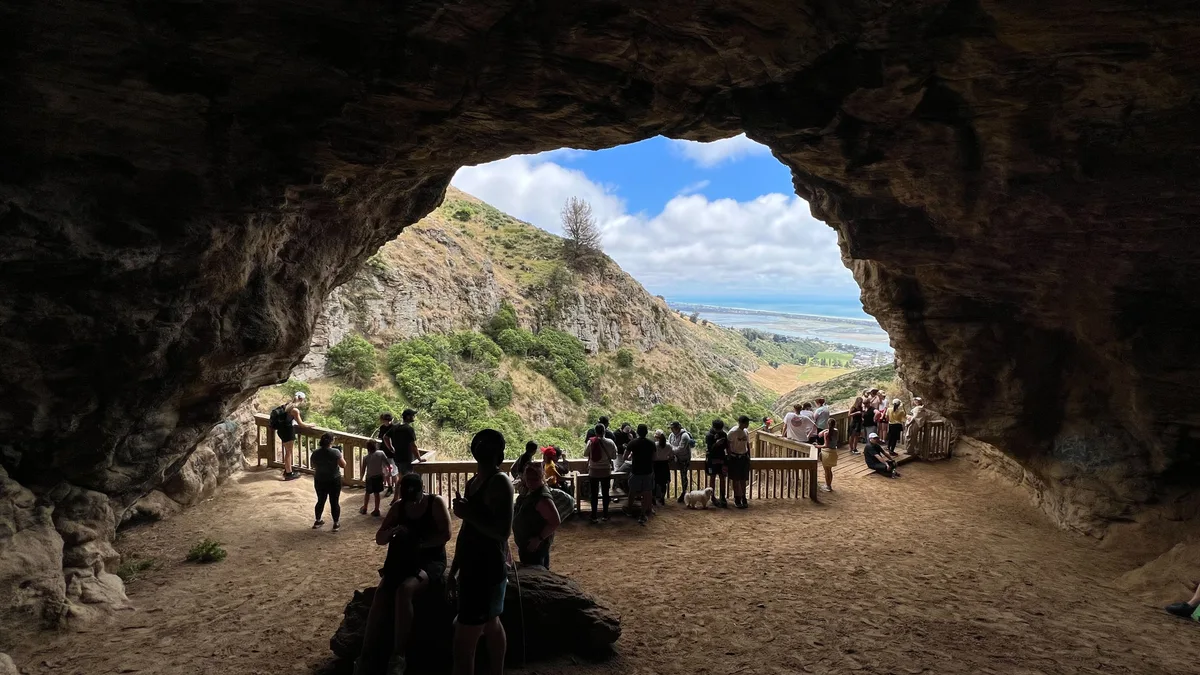
At the head of the walk is the cave. It’s not a tunnel into the dark. It’s a broad overhang in the volcanic rock of the old Lyttelton volcano, the kind of shelter these hills are known for. Its scale catches visitors off guard, given that the start is a suburban park.
What you walk into
The walk starts on the flat, grassy floor of the park. The valley walls close in quickly. The path turns into an earth-and-rock track that climbs gently, with native and regenerating vegetation on either side and craggy outcrops above.
The cave opens at the top. Expect:
- A wide, open-mouthed overhang instead of a passage you have to crawl through
- Rough, dark volcanic rock, the same rock that makes the Port Hills skyline
- A dry, sheltered floor under the lip, so it’s a natural spot to stop
- Views back down the valley towards the estuary side of Redcliffs
Once you’re inside the overhang, Main Road’s traffic noise mostly drops away. That’s a big part of the appeal. Christchurch has plenty of grander lookouts, but few that feel this tucked away and still sit ten minutes from a bus stop.
Getting to Redcliffs and the track
Redcliffs is on the coastal road between Ferrymead and Sumner, roughly 20–25 minutes’ drive from the central city. The Metro Purple Line bus runs along Main Road towards Sumner. Get off in Redcliffs village and walk up into the park from there.
If you’re driving, use the street parking near the park entrance and respect residents’ driveways. These are quiet residential streets. From the park, the walk up to the cave is short. Most people spend 45 minutes to an hour on the round trip, including time at the cave.

Reading the rock: safety after the quakes
The Port Hills took heavy damage in the 2010–2011 Canterbury earthquakes. Rockfall closed many tracks and caves around Redcliffs and Sumner for long periods. Some areas are still managed for rockfall risk, and the rules can change.
- Check the Christchurch City Council Port Hills track updates before you set out
- Obey any fencing or closure signs at the park, even when the track looks fine
- Don’t climb the rock faces above the overhang or pull at loose stones
- Stay out from under the lip after heavy rain or a felt aftershock
Treating the cave the way Christchurch does
This cave belongs to a local reserve, not a ticketed attraction. Nothing is staffed, and nobody hands you a map. How you behave keeps it pleasant for the next walker.
- Leave no trace. Carry out everything you bring, including food scraps. There are no bins at the cave.
- Keep your voice down. The overhang carries sound, and other walkers come up here for the quiet.
- Respect the land’s history. The caves and rock shelters along this coast have Māori and early settler associations. Don’t scratch, chalk or move anything.
- Go early or late in the day. Weekday mornings and evenings tend to be quieter, because weekend afternoons pull families and dog walkers into the park.
- Dress for the hills. The Port Hills weather turns fast. A wind layer matters more than you’d guess from the sheltered valley floor.
Pairing it with the rest of the coast
The cave fills a morning or afternoon well, and the coast around it rounds out a full day. Stay on Main Road and you can chain several stops together:
- Sumner Beach, a few minutes further on, with a long promenade and Cave Rock (Tuawera) on the sand
- Shag Rock (Rapanui), the quake-shattered stack at the estuary mouth near Moncks Bay
- Ferrymead Heritage Park, back towards the city, for a recreated Edwardian township
- Taylors Mistake, over the hill from Sumner, for surf and the start of coastal walking tracks
Afterwards, Redcliffs village has a small cluster of cafés along Main Road for a coffee on your way back to town.
Frequently asked questions
Where exactly is Barnett Park Cave?
It's at the head of Barnett Park, a reserve in a valley behind Redcliffs village on the coastal road between Ferrymead and Sumner in Christchurch. A short walking track runs from the park up to the cave.
How do I get there without a car?
Take the Metro Purple Line bus towards Sumner, get off in Redcliffs village, then walk up into Barnett Park and follow the track up the valley.
How long does the walk take?
Most people spend 45 minutes to an hour on the round trip, including time at the cave. The climb is short and fairly gentle, but the surface is rough earth and rock.
Is the track open and safe since the earthquakes?
Port Hills tracks and caves have been closed at times because of rockfall risk since 2011. Check the Christchurch City Council's Port Hills track updates before you go, and obey any signs or fencing on site.
What else is nearby?
Sumner Beach and Cave Rock, Shag Rock (Rapanui) at Moncks Bay, Ferrymead Heritage Park and Taylors Mistake are all a short drive along the same coast.
Plan your trip to Christchurch
New Zealand eSIM & staying connected →
Some links above are affiliate links — if you book through them, Wander Atlas earns a small commission at no extra cost to you. It's how we keep every guide free.
Related guides
 attraction
Christchurch Botanic Gardens: Travel Guide (4.7★)
 attraction
Whale Watch: Kaikoura Travel Guide (4.7★)
 attraction
The Church of the Good Shepherd: Lake Tekapo Travel Guide
 attraction