Stripes at five thousand metres
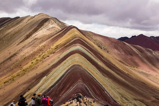
The colours really are there. They come from layers of mineral sediment tilted on end: iron oxide gives the reds, iron sulphide the mustard yellows, and chlorite the greens. The ridge stands at roughly 5,000 m, high enough that every step on the final climb takes effort.
For decades, snow and ice covered the stripes. They became widely visible only in the last decade or so, and Vinicunca went from grazing land to one of the Cusco region’s best-known day trips in a few years. To the east, the glaciated summit of Ausangate fills the skyline. At over 6,300 m, it is the highest peak in the region.
The road out and the climb up
Almost everyone goes on a tour from Cusco. Vans collect travellers from hotels in the early hours, drive south through the Vilcanota valley past Checacupe, then climb on a dirt road to a trailhead parking area at roughly 4,600 m. Breakfast is usually served at a stop along the way.
From the trailhead it is about 5 km to the viewpoint:
- Uphill: 1.5–2 hours for most people. The path is wide and gradual until a steep final zigzag.
- Downhill: about an hour on the same route.
- Horses: local herders lead them most of the way up, but not the last steep section.
- Add-on: some tours include the Red Valley (Valle Rojo), a rust-coloured basin seen from a short detour off the ridge.
Plan on a 12–14 hour day door to door. You can drive yourself, but road conditions and the altitude make a tour the sensible choice.
Altitude, weather and timing
Altitude is the real challenge here, not distance. Spend two or three days in Cusco or the Sacred Valley before you go, drink plenty of water, and turn back if your headache or nausea gets worse instead of settling.
The dry season (May–September) gives the clearest skies and the most saturated stripes. December to March brings rain, mud and sometimes snow that hides the colours completely. Even in good weather the summit is cold and windy, so pack:
- warm layers, gloves and a hat
- strong sunscreen and sunglasses
- snacks and a rain shell
Google currently lists the site as open 24 hours. In practice your visit is set by the tour’s arrival, which usually puts you on the trail mid-morning.
On the mountain, among the communities
The land belongs to local Quechua communities, and they run the checkpoint. Each visitor pays an entrance fee there. Tours often leave it out of the package price, so ask before booking, carry small notes in soles and check the amount posted at the gate.
Most tour vans arrive in the same wave. The viewing ridge gets crowded, and the photo spot at the top often has a short line. If you walk at a steady pace without long stops, you will usually reach the summit ahead of the main group.
Women in traditional dress sometimes pose with alpacas for photos. Expect to offer a small tip in return, and ask before you photograph anyone. Stay on the marked path: the slopes erode easily, and the fragile stripes are the reason everyone is here.
If Vinicunca seems too high or too crowded, Palccoyo is another rainbow mountain in the region. It is reached by a shorter, gentler walk.
Frequently asked questions
How far is Vinicunca Rainbow Mountain from Cusco?
It is about three hours by road, southeast through the Vilcanota valley. Most tours pick you up in the early hours and get you back to Cusco in the evening, a 12–14 hour day.
How hard is the hike?
It is about 5 km each way from a trailhead at roughly 4,600 m, ending just over 5,000 m. Most people take 1.5–2 hours to go up. The altitude is harder than the gradient, and the last stretch is steep.
When is the best time of year to go?
May to September, in the dry season, when skies are clearest and the stripes look brightest. From December to March, rain and snow can hide the colours.
Can I ride a horse instead of walking?
Yes. Local herders hire out horses for most of the ascent, but you will still need to walk the final steep section to the viewpoint.
Is there a less crowded alternative?
Palccoyo is another rainbow mountain near Cusco, reached by a shorter and gentler walk. It suits people worried about the altitude or the crowds at Vinicunca.
Plan your trip to Cusco
Peru eSIM & staying connected →
Some links above are affiliate links — if you book through them, Wander Atlas earns a small commission at no extra cost to you. It's how we keep every guide free.